Intertidal ltd
The Boatyard,
Barrow Haven,
Barrow-upon-Humber
Lincolnshire DN19 7ET
United Kingdom
Tel: +44 (0) 7778 192568
Internet: https://www.Intertidal.net
Email: enquiries@Intertidal.net

Intertidal undertakes hovercraft survey work to support science and engineering projects. We carried out our first survey in 1998 and we’re still going strong, continuing to work across the UK. We are based on the Humber Estuary, where we have our own facility and hovercraft slipway. For operations beyond the Humber, we are centrally located to serve the rest of the UK. Our staff have nearly 40 years of hovercraft operating experience, coupled with an industrial and academic background in water and sediment science.
Hovercraft Surveys and Sampling
Intertidal has developed safe and reliable methodologies for using amphibious hovercraft to access difficult environments. These include estuaries and inshore coastal areas, as well as ports, harbours, and rivers. Hovercraft are ideal for covering terrain rapidly where shallow water, sandbanks, mudflats, or strong tides make conditions impossible or dangerous for other vehicles. Sampling times are reduced because large distances over mixed land/water terrains can be covered rapidly. The hovercraft can be launched from slipways, beaches, flood banks or using a crane.
Intertidal can collect a range of sediment and water samples to analyse for chemical, biological, and physical parameters. We use a variety of sample collection techniques, including vacuum coring to take large samples of very soft sediment.
Additionally, we use our hovercraft as a survey platform for topographical and environmental mapping. In the last few years, we have increasingly used the hovercraft also as a platform for drone operations (quadcopter and fixed wing). Flying drones from a hovercraft extends the range and coverage of the drone. Significant synergies are possible from combining these two platforms and this area is developing rapidly. If you have a specific project in mind, then please get in touch. We are passionate about leveraging technologies to extend the scope of what we can achieve in the field.
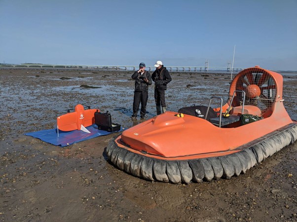
Mapping using a fixed wing drone
Analytical Services
Formerly part of one of the UK’s leading testing laboratories, Intertidal has access to a full range of laboratory facilities for chemical, physical and ecological analysis to recognised accredited standards. Intertidal can also assist with the design of sampling schemes, sample preparation, data handling and reporting. We offer an optimisation service to ensure that clients’ sampling and survey strategies are properly aligned with the tidal regime and hovercraft operating parameters in the target area.
Intertidal Clients
Intertidal’ s client list includes organisations with responsibility for environmental regulation, monitoring and conservation. We also work with civil engineering and energy companies, ports, local authorities, and agencies with responsibilities for harbours and flood defences. Intertidal frequently undertakes work for independent environmental and engineering consultancies. We also work for universities, research institutions and charities. We may be able to offer significantly reduced rates for non-profit work in support of conservation objectives, please get in touch if this is of interest.
Making Contact
If you have a survey or environmental baseline or monitoring need in a difficult to access area do make contact and we will look at the challenge together. All it needs to start is an email to our enquiries address above or a telephone call.
For information on our privacy policy please click on the Button